
Ephesus’s two agoras were not an accident of growth. They followed Aristotle’s prescription for a proper Greek city: a “free” political agora kept clear of trade — the State Agora — and a separate commercial agora for merchants1. This one, known in antiquity as the Tetragonos Agora, stood within about 100 m of the Great Theatre, a proximity that Strelan notes matters for reading the crowd that gathered there during the Acts 19 riot2.
Two agoras, one city plan
The square’s earliest phase goes back further than its Roman rebuilding. Lysimachus’s original Hellenistic lower agora, Rogers writes, was laid out as a rectangular grid of two blocks, each about 160 × 224 ft, with a warehouse at its southwest corner dating to the early 3rd century BC — a commercial function from the very start3. Groh finds that a Hellenistic storage building under its west side measured about 17.2 × 43.4 m, two rows of nine roughly square rooms linked by doors, with a gravel street between it and a second Hellenistic building that was later widened from about 5 m to 8 m4. Centuries later, both the Commercial Agora and the new State Agora precinct were laid out on equal square grid plans under Augustus, using blocks of 179.79 English (185 Roman) feet, per Rogers’s reading of the measured city plan — the Roman grid superimposed on Lysimachus’s older commercial one5.
What size was the agora, really?
Two figures for the agora’s size circulate, and they are not in conflict, though a page could easily make them look that way. The open inner courtyard measures 111.89 × 111.39 m, confirmed independently by Rogers and by the excavation reports6. The whole enclosed complex, including its two-storey colonnades, runs to about 154 m per exterior side and roughly 24,000 sqm overall — this is the primary excavator’s own measurement, not a rival opinion, and the two figures simply describe courtyard versus whole building6. Rogers writes that rebuilding the square into that larger, post-earthquake footprint after AD 23 required moving Marble Street eastward into the lower slopes of Panayırdağ7.

The Gate of Mazaeus and Mithridates
The South Gate is precisely dated to 4/3 BC by its own inscription, funded by the freedmen Mazaeus and Mithridates in honour of Augustus, Livia, Agrippa and Julia, and measures 16.91 × 6.30 m8. That date is confirmed independently by Groh’s stratigraphic excavation of the square itself9. The Greek version of the inscription is a deliberate diplomatic rewrite rather than a translation: it drops the honorees’ names entirely, addressing “their former masters and the people” instead, since ordinary Greek-speaking Ephesians would not have welcomed such open imperial flattery, on Elliger’s own reading10. Rogers holds that before the agora’s later expansion, this gate had been the triumphal arch from which the sacred procession to Ortygia, Artemis’s mythical birthplace, departed; only afterward did it become merely the agora’s South Gate11.
Where exactly a well-known warning inscription stood is disputed. Elliger places the “whoever urinates here will be prosecuted” text at the Commercial Agora’s West Gate, tying it explicitly to the Aristotelian two-market logic above12. Harrison, citing Erdemgil, instead places a warning graffito in the apsidal niche of the Mazaeus-Mithridates Gate’s eastern passage — a different gate12. The excavation report independently documents a no-urinating inscription as part of the West Gate’s own fabric, alongside worn water basins and two building phases, which leans the balance toward Elliger’s placement without settling it outright — these may still be two separate inscriptions rather than one misattributed one12.
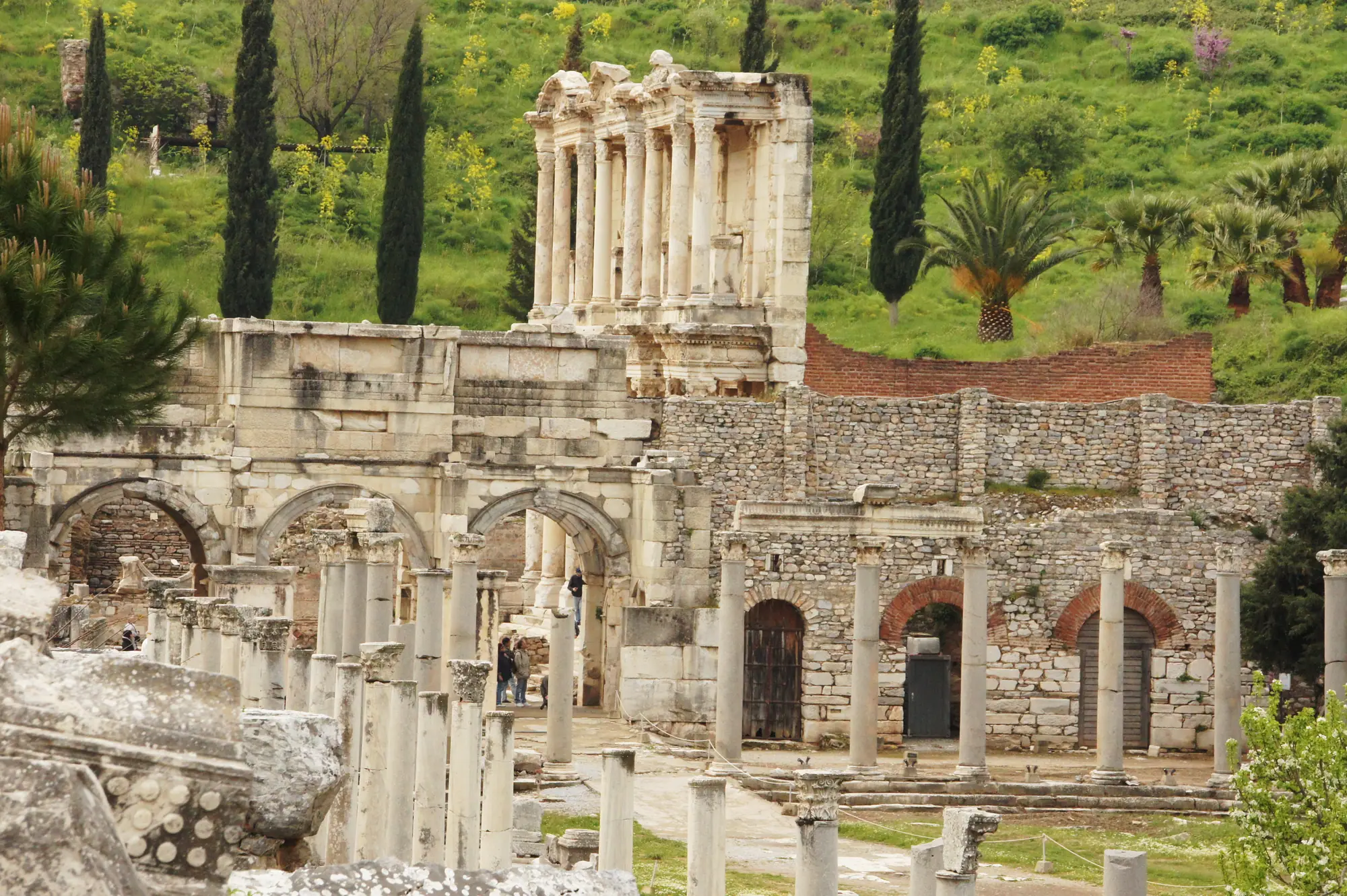
Building and rebuilding, Augustus to Nero
The West Gate is the oldest datable element of the agora, going back to around 100 BC on the excavators’ own dating13. In AD 43 an equestrian statue of Claudius, funded by Roman citizens doing business in Asia, was set up as part of the reopened agora, alongside statues of Claudius and possibly Messalina14. Harrison and Welborn write that from AD 54 the Eastern Hall was separately dedicated to Artemis, Nero and Agrippina14, and a further municipal building at the agora, possibly a fish market — the identification stays explicitly tentative in Harrison and Welborn’s own account — was dedicated to Nero and Agrippina from the same year15. Elliger records that under Nero a Doric colonnade more than 150 m long, two aisles deep, was added along the agora’s east side, facing Marble Street16.
The excavation report finds that a building inscription records the agora’s South Gate was rebuilt under Tiberius, and in doing so reveals the crossroads area’s official ancient name: the Triodos, a three-way road junction predating the Lysimachan grid — evidence that the Roman gate kept the old diagonal road alignment rather than squaring up to the new city plan17.
The slave market
Harrison and Welborn note that no physical slave market, or statarion, has ever been located at Ephesus, but its existence is confirmed epigraphically, including a statue base dated AD 42/43 honouring the Asian proconsul as “advocate” of those doing business in the slave market18. They add that a former slave, Ti. Claudius Secundus, was later honoured with an unusually large statue, paid for by the very traders who did business in that market — a striking reversal of status19.
Market administration and daily life
Agoranomos, or market-official, inscriptions carved on the South Gate confirm the square’s trading function through the 1st to 3rd centuries AD; a second Greek copy of the Persicus edict, found in 1926 near “Wood’s Basilica,” was reworked into a pillar that also carries separate agoranomoi inscriptions, which Keil suspected came originally from this same gate20. A building inscription found near the West Gate records that the agoranomos Timon erected two buildings in the centre of the agora in the 60s BC, a Parastas and a Horologion, or sundial monument. A separate excavation-report source instead dates the paving of “the Agora” by a Timon to around 80 BC, on letter-form comparison — a roughly twenty-year gap that may reflect two different men named Timon, or a single confused attribution, and is left here as an open cross-reference rather than a resolved fact21. Harrison and Welborn note that a graffito on a column of the agora’s east hall grumbles about a pompous person, likely aimed at Ephesus’s self-important elite, whose endless public honours were a running theme of civic life22.

Late antiquity and the agora’s end
Foss writes that the agora’s west entrance was remodelled, probably in the 4th or early 5th century, with cattle ramps cut through the wall — evidence the square had become primarily a cattle or food market, even as it still hosted the crowds of the 431 council against Nestorius23. He also notes that a dedication to Julian shows it still functioning in his reign, 361–363, and columns from the destroyed Temple of Domitian were reused in its south colonnade24.
The agora was finally abandoned in the early 7th century. Coin evidence across every excavated area of the city, from the Magnesian Gate to the agora itself, ends consistently in the reign of Heraclius, and one scholar, Hellenkemper, ties the city’s abrupt end-of-use horizon to an earthquake in AD 616, also attested at Sardis25. After regular urban use ended, the excavator reads the evidence — narrowed gates, walled-up doorways, loopholes cut into the south wall, monuments systematically cleared rather than left to decay — as conversion into a fortress or parade ground, dated by coin evidence to the 620s–630s26. Foss records that in the Byzantine period the old square was kept as an open field of ruins rather than built over, with a street running through it toward the former Embolos, and a middle-Byzantine fresco of a saint in a former shop suggests one room became a roadside chapel27.
Which square the late-antique name “Foros Theodosianos” actually referred to is genuinely unresolved, among three or more named scholars. Alzinger connected it with the State Agora; Wilberg linked it to this Commercial Agora instead; the excavation report’s own author concludes it most likely named neither, but a square along the Arcadiane, possibly the stepped plaza by the theatre. F. A. Bauer separately reads the inscription’s first line as an abbreviation referring to Christ and Mary Theotokos, which would tie the name to the Council of Ephesus in 431 — a reading the report’s own author does not accept28.
Edward Falkener’s 1845 map of Ephesus already correctly labelled this square “Agora venalis,” the trading agora, though he wrongly identified the Xystoi sports grounds as the civic forum — the Victorians got at least this one right29.
The square sits between the Great Theatre it stood so close to and the route down Harbour Street toward the vanished sea, both part of the wider walk through the ancient city.
Sources
Each source is listed once. The numbers link back to the claims it supports; dates show when the source was checked.
- Elliger 1985, 64 1, 8, 10
- Strelan 1996, 143 1, 2
- Rogers 2012, 68 3
- Groh 2006, 6 4
- Rogers 2012, 95 5
- Institut 1923, 372 6
- Rogers 1991, 100 6
- Scherrer and Trinkl 2006, 372 6
- Rogers 2012, 136 7
- Institut 1923, 30 8, 14
- Groh 2006, 17 9
- Rogers 2012, 137 11
- Elliger 1985, 65 12
- Harrison and Welborn 2018, 34 12
- Institut 1923, 35 12
- Institut 1923, 101 13
- Harrison and Welborn 2018, 201 14, 15
- Elliger 1985, 68 16
- Scherrer and Trinkl 2006, 55 17
- Harrison and Welborn 2018, 37 18
- Harrison and Welborn 2018, 38 19
- Scherrer and Trinkl 2006, 11 20, 21, 28
- Wankel 1979, 99 20
- Institut 1923, 105 21
- Harrison and Welborn 2018, 56 22
- Foss 1979, 63 23, 24
- Institut 1923, 108 25
- Scherrer and Trinkl 2006, 54 25, 26
- Foss 1979, 134 27
- Scherrer and Trinkl 2006, 1 29